Automatische Truppenführung im ZGS-14
Nicht dargestellt sind hier die Großquadrate der Flugmeldenetzkodierung und Meldelinien.
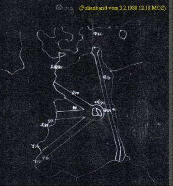
Die markierten Zonen zeigen den Verlauf der „Zeitweiligen Luftverbindungswege von und nach Berlin“ der Alliierten Siegermächte und die im Ostteil der DDR durchlaufende internationale Luftstrasse.
Die Form des Zielzeichens wird von Typ und Kurs des Objektes bestimmt:
Das Ziel nördlich von Berlin mit der laufenden Nr. 91 stellt ein Luftziel ohne Kennung dar und wird außerdem noch vergrößert gezeichnet, weil es neu angemeldet wurde.
Zur besonderen Beachtung werden tieffliegende Ziele hier rot gezeichnet.
Das Ziel Nr.69 im Nordosten der DDR ist ein eigenes gemeldetes Flugzeug mit südlichem Kurs.
Weitere Daten der Zielcharakteristik, wie die Nummer der funktechnischen Truppen, Geschwindigkeit, Höhe, Kurs, Bestand u.a.m. konnten sich die Operatoren auf den individuellen Displays abrufen.
Die Angehörigen des ZGS-14 hatten eine verantwortungsvolle Aufgabe zu erfüllen:
Rund 7000 Kampfflugzeuge der NATO und des Warschauer Vertrages waren insgesamt im Verantwortungsbereich einsatzbereit.
Die gefährlichste und größte Waffenkonzentration der Welt.
Bis zu 50 und mehr ausgewählte Ziele gleichzeitig auf der Leinwand waren keine Seltenheit im täglichen Dienst.
Wenn dann die strategischen Aufklärer SR-71 mit 3600 km/h oder eine Gruppe Kampfbomber F-4 direkt die DDR-Grenze anflogen, schrillten die Alarmsirenen auch im „Fuchsbau“ Fürstenwalde.